


COLONARD-CORUBERT

daniel77
User
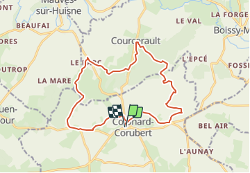

Length
16.1 km

Max alt
248 m

Uphill gradient
349 m
Km-Effort
21 km

Min alt
157 m

Downhill gradient
348 m
Boucle
Yes
Creation date :
2016-07-07 00:00:00.0
Updated on :
2016-07-07 00:00:00.0
6m
Difficulty : Easy

FREE GPS app for hiking
 SityTrail
IGN / Geographical institutes
SityTrail Plus
The world is yours!
About
Trail Other activity of 16.1 km to be discovered at Normandy, Orne, Perche en Nocé. This trail is proposed by daniel77.
Positioning
Country:
France
Region :
Normandy
Department/Province :
Orne
Municipality :
Perche en Nocé
Location:
Colonard-Corubert
Start:(Dec)
Start:(UTM)
326395 ; 5364430 (31U) N.
Comments